
How satellites can protect planet Earth from disaster
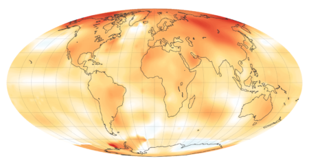
It might not look it, but our planet is a fragile place. A delicate balance of pressure, temperature andgases keeps us alive, as our atmosphere lets in enough heat for us to thrive – but not too much that we get too toasty. For many years our planet has looked after itself with ease. Now, with humans on the scene, things are changing more than ever, from climate change to mass deforestation. If our planet is going to survive long into the future it’s going to need our help.
Fortunately, we’ve got plenty of missions that are working for the benefit of our world already. Using observation satellites in orbit, scientists have been monitoring Earth for decades, watching how the planet pulsates and changes over time. From orbit we can watch how species migrate, identify and predict environmental changes and even fix problems.
A great example of this was the global effort to repair a hole in the ozone above the Antarctic back in 1987. Two years prior, scientists had discovered that chemicals known as chlorofluorocarbons (CFCs) – produced by fridges and aerosols, among other things – were causing the hole to grow. As a result countries around the world agreed to phase out the use of CFC as part of the Montreal Protocol. In early 2018, NASA announced that its Aura satellite had watched the hole successfully close, with it expected to fully repair as early as 2060. It was proof that we could work together to change the planet for the better.
Aura is part of a broader NASA project called the Earth Observing System (EOS). This programme, which began in 1997, has seen NASA launch missions and instruments into orbit. This has included the groundbreaking Landsat series of satellites, which have provided surface images of the whole globe. Then there’s the Terra mission that launched in 2009 and studies clouds, sea ice and more from orbit. Most of these satellites are in polar orbits, which means they orbit the planet from top to bottom so that it rotates underneath and gives them a global view.
Planning for the EOS began back in the 1980s, with NASA keen to regularly fly instruments for at least 15 years. “Human activity has altered the condition of the Earth by reconfiguring the landscape, by changing the composition of the global atmosphere, and by stressing the biosphere in countless ways,” they noted in a handbook in 1993. “There are strong indications that natural change is being accelerated by human intervention.”
More than two dozen missions have been launched as part of the EOS to date. Among the programme’s many accomplishments, scientists watched as an ice shelf collapsed on the Antarctic Peninsula in 2002 using the Terra satellite. The same satellite, along with the Aqua satellite launched in 2002, has provided a global view of how the vegetation cycle changes over the course of a year and the effect the climate has on it. Those same two satellites have also allowed us to see how summer sea ice in the Arctic is decreasing, which means that more of the Sun’s light is being absorbed rather than being reflected, raising global temperatures.
The EOS has helped in other ways too, such as enabling scientists to keep a close eye on the levels of toxic gases like carbon monoxide being emitted from massive fires in the atmosphere. This allows people on the ground to be alerted to these dangers, and they can in turn be advised to limit their outdoor activity to protect their health. The EOS is even helping to track and monitor rare animals, such as chameleons in Madagascar. Here, scientists have been able to use satellite imagery, combined with known habitats of the animals, to map out where they are likely to be living. It would take survey teams on the ground thousands of years to replicate this information without satellites.
It’s not just NASA that has been keeping a close eye on the planet. The European Space Agency (ESA) runs the Copernicus project, billed as the world’s largest single Earth observation campaign. Previously known as the Global Monitoring for Environment and Security (GMES) programme, it began with the launch of the Sentinel-1A satellite in April 2014. This radar imaging satellite provides images both day and night and during all weather conditions, and these are being used to map sea ice, track oil spills and more.
This has been followed by half a dozen more missions, with the latest – Sentinel-3B – launching on 25 April 2018. This mission is focusing on monitoring the behaviour and health of the oceans, but it has a wide range of abilities. It flies in formation with its predecessor, Sentinel-3A, and together the two of them can provide global data for Earth across an entire day. The satellites can measure the temperature over oceans, as well as the colour and height of the sea. They can also monitor wildfires from space, check the health of vegetation and map the way that land is being used around the world. And there are more Sentinel satellites on the way. In the coming years we’ll see the Sentinel-4 and Sentinel-5 missions launch, studying the composition of our planet’s atmosphere, while Sentinel-6 will measure global sea surface height for ocean and climate studies.
“Copernicus will help shape the future of our planet for the benefit of all,” said the ESA, also noting that it isthe “most ambitious Earth observation programme to date,” one that will provide accurate and timely data on the environment, climate change and more. All of this data is vital for directing climate policy and other human activities on Earth. By observing our planet around the clock from space we can see the direct effect that humans are having on it.
These are not the only climate-monitoring missions run by NASA and the ESA. The former has a number of other missions, including the Deep Space Climate Observatory, which observes the sunlit side of Earth. The latter has eight missions on the books in its Earth Explorer programme, including a mission to study how Earth’s gravity field varies over the surface of the planet, called the Gravity field and steady-state Ocean Circulation Explorer (GOCE), which ended in 2013.
In 2016, countries of the world came together to sign the Paris Climate Agreement, a global effort to reduce carbon emissions to prevent the global average temperature rising by two degrees Celsius above pre-industrial levels. While the US later infamously reneged from this agreement, it was proof that with enough level-headed minds, minds that can see the data from missions showing how the planet is changing, t we can take action. Humans continue to have a major effect on the planet, for better or worse, and monitoring that change is vital to our planet’s survival.
For more science and technology articles, pick up the latest copy of How It Works from all good retailers or from our website now. If you have a tablet or smartphone, you can also download the digital version onto your iOS or Android device. To make sure you never miss an issue of How It Works magazine, subscribe today!